Digital photogrammetry
Kothari Industrial Corporation Limited has been delivering Digital Photogrammetric solutions through a technically skilled team based in Chennai and across India. Over the years, we have been at the forefront of technological advancements, playing a key role in driving innovation. Our derived products undergo rigorous quality control procedures to ensure exceptional standards. All digital photogrammetry services are executed using advanced softcopy workstations equipped with the latest, proven software tools.
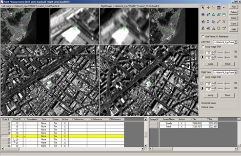
Aerial Triangulation (AT)
Aerial Triangulation in Photogrammetry is the method of determining and calculating 3-dimensional object coordinates by photogrammetric means,by using photographs exposed from different positions, covering the same object.
Digital Elevation Models (DEM)
A digital elevation model is a regularly-spaced bare-earth raster grid referenced to a common vertical datum. When you filter out non-ground points such as bridges and roads, you are left with a smooth digital elevation model.
Digital Surface Models (DSM)
DSM measures the height values of the first surface on the ground. This includes terrain features, buildings, vegetation and power lines etc. DSM therefore provides a topographic model of the earth's surface.
Digital Terrain Models (DTM)
Digital Terrain Modelling (DTM) is the collection of mass points of elevations and 3D breaklines at each change of terrain using Summit Evolution softcopy workstations.
Planimetric Mapping
Planimetric maps develops natural features with their exact coordinate locations. These features are comprised of vegetation, trails, fences, utility poles, drainage systems, driveways, road boundaries and curbs.
Topographic Mapping
Topographic maps are detailed, accurate graphic representations of features that appear on the Earth's surface. These features include:
- Cultural
- Hydrography
- Relief
- Vegetation
Contour Generation
Contours are commonly in vector formats (e.g., shape file, dxf) and derived from a reconstructed TIN of DEM . Contours are among the most commonly used representations for elevations.
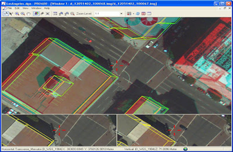
3-D Feature Extraction/Elevations
We provide accurate digital planimetric feature extraction for cartography mapping and 3D topo mapping in industry accepted standard formats.
Change Detection
Timely and accurate change detection of Earth's surface features is extremely important for understanding relationships and interactions between human and natural phenomena in order to promote better decision making. Remote sensing data are primary sources extensively used for change detection in recent decades.
Related Images

Aerial Triangulation

Digital Elevation Models (DEM)

Digital Surface Models (DSM)

Digital Terrain Models (DTM)
Digital Photogrammetry

Planimetric Mapping

3D Buildings

3D City Modelling
3d Vector Mapping